|
Day 2
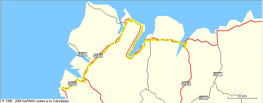
June 12th - Tongue to Scourie
As expected day 2 was not quite as good as day 1 but still not bad.
After the best fry-up of the trip so far I left the b&b at Tongue
at about 9.30. The weather was drizzly and after about a mile I decided
to go for the waterproofs. I didn't need them for long as I soon hit
a large incline and started getting warm. The drizzle soon eased off
but it remained grey. My right knee began twinging again but it was
no worse than yesterday so I was not too worried. This landscape was
much more like what I expected from the very north of Scotland - very
sparsely populated (if you don't count sheep) and a bit barren. My water
bottle soon became empty and I was looking for somewhere to get a refill.
Travelling south down the east coast of Loch Eriboll there were no signs
of life at all. Eventually I collared a passing postman and asked him
if there was a cafe or a shop nearby. He said there was a cafe about
2 miles down the road. 2 miles came and went and I had to resort to
filling my water bottle from a stream. The route south down the east
side of the loch was hard work because it was hilly and when I reached
the bottom and started to head north the road was flatter but now I
had a stiff wind in my face. It also felt a bit weird to be heading
north on a John O'Groats to Lands End trip but there is only one road
to the west coast so I didn't have much choice. Eventually, after what
felt like 5 miles after speaking to the postman I reached the cafe.
I had lunch and made sure I stocked up on bottles of water. The cafe
owner said there was only one big hill on the road to Durness. I asked
if it was an big uphill or a big downhill and everyone in the cafe had
a good laugh.
I got over the hill and it was a big relief to reach Durness. I had
a quick look in Smoo cave but I couldn't stop long as I had left my
bike unattended at the top of the footpath and I was worried about it
not being there when I got back. Fortunately it was ok and I made my
way towards Durness town centre. I stopped in a cafe, had the worst
cup of coffee so far and tried to decide if I should finish there for
the day or go on to the next town. I was getting regular route-advice
text messages from Kirsten which helped a lot. The cafe owner informed
me that the next town, Scourie was 26 miles away. I knew it was south
west of Durness so I would have the wind behind me and I decided to
go for it. I was glad I did - the road was mainly flat and had the best
scenery of the day. There was one really good downhill section that
seemed to go on forever and I averaged 30mph for a couple of miles with
no effort at all.
At about 6.30pm, having covered 58.9 miles I reached Scourie and started
to look for a b&b. The first one I tried was full, the second wanted
£40 for a single room and the third wanted £30 for a double
which was all they had. I went for that and soon after arriving I plodded
off to the local pub for a very nice gammon steak. I asked the barman
if it was possible to get a mobile phone signal anywhere in the town
and he replied with "Ye cannae . . . something . . .something .
. . something". I knew that no matter how many times I asked him
to repeat it I was never going to understand what he was saying but
I got the gist of it. If a mobile phone signal was such a no-no in Scourie
I thought it not worth asking about an internet cafe. My search for
a wifi hotspot goes on.
Today could have been a lot worse, I was travelling through open countryside
most of the time and if it had rained there would have been nowhere
to shelter. Also the bike was faultless for the second day running and
my decision to go on to Scourie turned out to be a good one. If I had
stopped at Durness I would only have done 34 miles and I would actually
have finished the day further away from Lands End than when I started
which would have been really depressing. My average for the two days
is now a little over 61 miles which puts me on target for a weekend
off before going back to work but there's a long way to go yet though.
The Routemap

The Speed (in blue) and the Elevation (in Green)

|

