|
Day 5
June 15th - Gairloch to Locharron
This was the first day that I didn't make it to my intended target,
Plockton but having spent half the day struggling into a stiff headwind
my legs went on strike at Locharron. I still managed 58 miles which
puts my daily average at about 56 so I'm still just above the magic
55.
Firstly I should say sorry to the school group at the youth hostel who
did not make a sound all night. Those earplugs I packed still haven't
been needed yet. Because the hostel is self-catering I had to go without
my fry-up again and had to make do with some fruit (yuk!) from the shop
in town after which I headed off. There was an easterly wind blowing
today and, as I started off heading south-east I had it in my face making
it really hard-going. Most of the route was through open countryside
alongside Loch Maree so there was nothing to block the wind and at times
I had to pedal downhill to keep going. I knew that, at Kinlochewe, 20
miles down the road I would be turning right onto the A896 and going
south-west and hoped that it would then be behind me. When I got to
Kinlochewe I stopped for a coffee and a bacon roll and got talking to
a motorbiker who turned out to be from Taunton and whose mother used
to live in Combe St Nicholas where I work. Small world eh ?
Luckily when I turned right the wind was behind me and was being funnelled
down the valley, it was the quickest 10 miles of the whole trip and
such a relief after what had gone before. However it was on this stretch
that I had my first technical problems, if I can call them that. I decided
to be clever and take some video while I was bombing along so I held
the camera in my right hand and started filming. Then a cattle grid
(which I usually cross as slowly as possible) appeared out of nowhere.
I braked as hard as I could with my left hand and the cable snapped
leaving me without a back brake. I went across the cattle grid at about
20mph. Hopefully I stopped recording before I started swearing. My first
thought was for my laptop in the back pannier which I knew would not
like being shaken about but it survived ok. It turned out that the brake
cable hadn't broken but had just slipped in its clamp and turned out
to be an easy fix.
Shortly after the cattle grid incident I was back to doing 25 mph ish
along the same road when I noticed that the gps was showing 12mph. I
watched it for a while and saw that the display wasn't changing at all.
I tried to restart it but it didn't want to know. It was only when I
held the 'off' button in for 3 seconds that it reset itself. Having
just downloaded the data I appear to have lost everything before this
point. Luckily I also have the vdo bike computer so I still know how
far I've gone but the map, speed and elevation stuff for today is half-missing.
Modern technology !
After this 10 mile bit of high-speed stuff I reached a place called
Torridon and the hills started again. At the top of the first big climb
I got my first, distant view of the Isle of Skye where I hope to be
tomorrow. Needing another coffee I turned off into a little village
called Shieldaig which is basically a row of houses with a shop at the
end. It overlooks a beautiful bay with an island in the middle. I'm
running out of words to describe this scenery.
When I got back onto the main road again either I changed direction
or the wind did because it was back to being a headwind again. For the
first time in the whole trip I was faced with some large uphills into
the wind (including one up through a canyon which looked like something
out of a road-runner cartoon).
Eventually I reached Locharron and asked for directions to Plockton.
A lady described the route and mentioned a steep hill a few miles out
of town. I decided to have something to eat in Locharron and then could
just not face another 12 miles including that hill so chose to call
it a day. At the fourth attempt I found a really nice b&b overlooking
the loch.
Tomorrow I'll go into Plockton (the town where Hamish Macbeth was filmed)
and then I'm following Kirsten's detailed directions around the Isle
of Skye. So far on this trip the only wet stuff I've hit was 10 minutes
of light drizzle as I left Tongue but from what I've heard on the weather
reports that could all change soon. I just hope it doesn't turn nasty
tomorrow and spoil the Skye views.
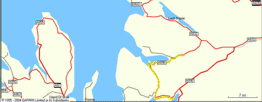
The Routemap which should have started north west of Loch Maree (where
the B8021 marker is)

The Speed (in blue) and the Elevation (in Green) for the last 28 miles
of the day

|

