Day 7
June 17th - From Armadale, Isle of Skye to Fort William
I got quite a surprise when I checked the map today. I thought the
scenic route down the west coast would have added 70-80 miles but, in
fact, it has added 165. My original route to Fort William would have
got me here in 226 miles but I have actually done 391. I think it is
quite an achievement to be 3 days behind schedule when I've only been
going a week ! I do realise that I have seen some really great places
that I would have missed if I had taken the direct route down the A9
so it's not all bad.
Anyway I had planned to start the day by getting on the 9.40 ferry to
Malaig but texts from Kirsten persuaded me to have a quick look around
southern Skye before leaving so I did an 8 mile ride to the west before
heading back to the ferry for the 11.10 sailing. I climbed a rather
large hill first thing and got a view of west Skye but didn't have time
to go too far across.
On the way back down the hill I encountered two sheep standing in the
middle of the road. Nothing unusual there but instead of just standing
there or running into the nearest field these two decided they were
going to run down the hill in front of me. I even tried shouting "It's
ok - I'm not welsh" but they weren't stopping. It was so funny
to watch I decided to video it but after a while I thought I should
stop to give them a rest. I waited about a minute then set off again
and around the next bend there they were again, still running. Eventually
they turned left into someone's drive. That was their exercise for the
day.
I felt like a bit of a cheat on the ferry, it was like getting a lift
part of the way but having added 165 miles to my route I hope I can
be forgiven. It was a very long way round otherwise. On the other side
Mallaig didn't have much to offer so I got on the main road to Fort
William, signposted as being 46 miles away. After a few miles I saw
another cyclist with full panniers coming towards me. He turned out
to be an Australian doing the end-to-end in the opposite direction.
He told me I had to visit the Isle of Arran but I had already decided
that from now on it was the direct route home.
I stopped for lunch at the Lochailort Arms pub on route and got talking
to a dry-stone waller by the name of Jimmy MacKenzie, another great
scottish name. He was also a bit of a cyclist and warned me about the
hill that was waiting for me 6 miles down the road. It was known by
locals as the 'Mooee' (probably not how you spell it but that's how
it sounds). The Australian cyclist had also mentioned it so I was expecting
the worst. When it appeared it didn't seem that bad, it dragged on a
bit but I've been up a few steeper ones this week. Once at the top there
was a downhill stretch and then I got my first sight of Ben Nevis in
the distance. I could see the top of the mountain but there was a ring
of cloud around it about half way down. The youth hostel I was aiming
for was right at the foot of Ben Nevis so I could see exactly how far
I had to go and the road I was now on was a really good, flat one that
took me all the way into Fort William. When I arrived at the youth hostel
the sun had come out and it was now really warm. I could see lots of
tired looking people descending from the mountain. Nutters !
I'm hoping the land will flatten out a little now, according to the
locals the route to my next stop at Oban is fairly level. I did 56 miles
today and felt like I could have done more despite my dodgy left knee.
I don't think I have much chance of finishing this in 20 days, if I
am to do so I will have to 440 miles for each of the next two weeks.
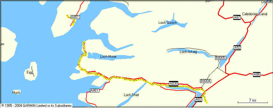
The Routemap

The Speed (in blue) and the Elevation (in green). I think there's a
problem with the speed scale, I wasn't really going this slowly all
day.

|

